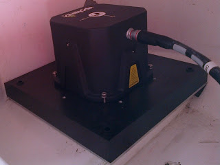
POS MV is a GPS Aided Inertial Navigation System. POS MV blends GPS data, together with angular rate and acceleration data from an IMU, and heading from GAMS to produce a robust and accurate position and orientation solution.
With
single control unit for two DGPS antennas and one IMU, it makes the survey
spread reasonably compact and easy to mobilise, it has five input /out put
serial ports with NMEA Binary and other options. One USB connection, UDP
Ethernet port 5602 with receiver slot no. on QINSy 102 and 103 and one BNC
connector for PPS. It is designed
to be a complete integrated solution for measurement of position (latitude,
longitude and altitude), orientation (roll, pitch, and heading), heave,
velocities and performance metrics.

To find out the Pos MV IP address, connect serial cable to Com 4 and check on HyperTerminal with 9600 bauds.

IMU is also employed for Inertial Navigation,
to compute a position from its measurement rather than using it just as a
motion compensation unit. With a known Position is given to the IMU, it will be
able to integrate acceleration and angular rate to determine its displacement
and calculate a new position. Thus allows working in poor GPS environments.
For navigation POS MV has provision for two Auxiliary GPS inputs
used to input a corrected position and two Base inputs used to input
corrections.
POSMV combines the best of both - GPS and
Inertial systems. The IMU and GPS work together so that even if GPS drops out the
system can still provide a robust solution.
POS MV 320 uses Inertially aided RTK technology.
The system provides position, heading, altitude and heave data using inertial /
GPS technology. Its high update rate is specifically useful for Multibeam
systems enabling adherence to IHO standards on sonar width of greater than ± 75 degrees under all dynamic conditions.
GAMS (Gps Azimuth Measurement System) calibration relies
on the vessel making a series of dynamic maneuvers, making the IMU heading data
as accurate as possible. The GAMS calibration is easy with
only the offsets and liver arms to be correctly measured and entered in the
software followed by rotational movements in the figure of eight preceded by a
straight line.Once
this has been achieved the system self calibrates and calculate a separation
and XYZ offset. Multiple calibrations are to be conducted and results post
processed to check for uniformity.
GAMS computes a carrier differential GPS position solution of an Antenna
B with respect to an Antenna A and thereby computes the heading of the A B
antenna vector baseline vector. It uses roll, pitch and heading from the S/D
navigator to aid in the resolving of phase ambiguities and to check the
validity of the GAMS solution. GAMS being self-calibrating; the user can
place the antennas anywhere on the vessel. GAMS will measure antenna baseline
with respect to IMU axes with no need to survey in components. GAMS Provides
heading aiding to the IMU data.
IMU will drift over time when sailing in a
straight line, IE running a survey line…
GAMS Aiding help the system produce a reliable
heading solution when long straight lines are run the system looks at
differences in the carrier phase signal to determine heading from the dual
antenna system. It only need to know the relationship between the two antennas to do this
well.
One of the few limitations is that
at certain locations good satellite coverage is unavailable so the position
accuracy may be beyond acceptable limit for some time.
Another limitation is that the differential is not Real time
unless you have a Reference station setup for RTCM input. It takes up to three
days to visualise the final processed data in the processing software POS
Pac.
POS Pac with reference to the recorded raw position observation log file finds the Base Stations, download, and import
base station data which is publicly available on the internet. It also downloads
precise and broadcast ephemeris files.
POS Pac scans imported base station files to ensure
quality. Quality Check requires 18 hrs of continuous data and precise ephemeris files from
three days (previous, present, and next).
It performs a network adjustment
on the station coordinates, with one station selected as the control station. SmartBase
QC will recommend action, but the user should still apply some “local
knowledge”
GNSS and Inertial observables are
simultaneously processed to create the Smoothed Best Estimate of Trajectory
(SBET) solution. The Raw files (.001) finally get to be processed (sbet_----.out).
POSPac MMS provides a PPP (Precise Point Positioning) solution. PPP is a
robust and easy to use solution providing decimetric levels of accuracy no
matter how far the shore or GNSS base station infrastructure.
IN-Fusion PPP provides increased solution robustness
with radically simplified workflow
It also provides the capability to maintain PPP
convergence should the number of satellites tracked drop temporarily.
POSPac MMS can estimate errors in lever arms
applied in real time, this is often useful in
validating both the surveyed values, and the interpretation of those values.
Finally observables from POS MV, public and
dedicated GNSS base stations, as well as precise clock and ephemeris data are
all used to produce the optimal result. The time budget is three days for the
same.
In all it is a robust, easy to mobilize,
calibrate and operate.


No comments:
Post a Comment